
So here we are in Utah near Provo looking at Mount Tipanogas. Viewed from the southwest, Mount Timpanogos resembles the profile of a sleeping woman. Various legends are told of an Indian maiden who died of grief after her lover was killed but there is no evidence that any of these are actual Native American myths.

Looking northwest we could see more peaks that surround Salt Lake Valley.

When Sharyn and I moved to Utah in the 70's the smoke from the cars and this Kennecott copper mine was so thick we didn't see any mountains until we were almost to Ogden in the north end of the valley.
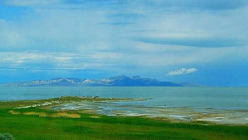
Antelope Island may look distant in this picture but it isn't very far and sits in the Great Salt Lake Nolrtheast of Salt Lake City.

Stansbury Island was much closer and is directly east of Salt Lake City.

I can't tell you how tight it was pulling into this rest stop on I-80. These two trucks were the only vehicles and there was only inches on either side pulling in.

They had a few historic signs in the rest area Jedediah Smith must have really gotten around because there is a park near the coastal border of Oregon and California named after him.

Then it was back onto I-80 moving west.

We stopped at a MacDonald's for a breakfast snack and I got some pictures of Yellow Headed Blackbirds...

... then passed a Morton's salt mining operation on the Great Salt Lake.

If I had needed any salt for my snack there was plenty here.

Just into Nevada Sharyn got a picture of Pilot peak

We stayed for the night in Winnemucca, Nevada in a very nice RV park and I got this picture for Peter of the RV of person doing very well...

... in the tattoo and piercing business and located in Montana.

One of the long timers in the RV facility had a little art show going on for some kids.

In the morning we picked up some items at the grocery store and off we went.

We took the road less traveled, Highway 95, and just loved the scenery...

... and did see lots of cattle, these are but a few.

After many miles we took off on highway 78 (Steens Highway) west towards Burns, Oregon and saw some of the most desolate but beautiful country we have eve seen. The gravel is NOT the road but a pullout. The road was a very nice two lane highway and very smooth.

It was the perfect time of year with lots of greenery...

...and lots of nothing else including cell phone service.

We saw only three cars for the next hour and a half.

I like these pictures but they cannot convey the immense vistas here.

Then the storms we heard about started rolling in and for the rest of the day we went from sun...

... to snow...

... to more snow...

... and more snow in brothers, Oregon ...

... to sunny and mild. I guess the high desert isn't always hot and dusty.


Then driving over McKenzie Pass we found some snow at the summit and finally lots of rain at home. I considered building an ark thought better of that idea. The trip ended safely after driving almost 5,000 miles. I was thankful I had Sharyn along to navigate and plan, guide and oversee most things. It makes the long drives all the easier to do.
Scrabble Score Scrabble Queen 312 - The Contender 334
Quote of the Day ~
"The woods are lovely, dark and deep. But I have promises to keep, and miles to go before I sleep." ~ Robert Frost American poet, 1874-1963
No comments:
Post a Comment