Friday, September 30, 2011

Malheur Bird Refuge Trip

On the way to the Bird Refuge we stopped for a history lesson about the Bannock War.
"Five miles northwest of this location, one of the last battles of the Bannock War was fought in June 1878. The Bannock War began in May 1878 when the Bannock Indians of Southern Idaho became angered over treaty violations and increasing settlement. With the U.S. army in pursuit, the warring Bannock fled to this area and were joined by Wada Tika Paiute. On June 23, units of the 1st U.S. Cavalry commanded by Reuben Bernard attacked a camp under the leadership of Paiute Chief Egan on nearby Silver Creek. The battle continued into the night until Egan, severely wounded, led a retreat northward through the John Day Valley into northeastern Oregon. The tribes were defeated at Battle Mountain and surrendered after Chief Egan's death."

White Pelicans at Mulheur Lake 
Up ...


...Up...

...and away...


... while others sit and chat.

This is a wonderful place for birding and we barely got here,
what a treat...

...even the Grebes were there to greet us.

We checked into the Narrows RV Park a nice RV Park with good
 views as the sun began to set...

...and set it did with a bang.

We left the RV park headed to the Mulheur headquarters and
passed some beautifully arraigned round hay bales...  

... in huge quantities.

Finally after a short 6.3 miles we arrived at the headquarters where
we were greeted by Suzanne a volunteer at the center. After an
excellent orientation...

... we stepped out on the patio that overlooks a great pond
filled with all kinds of aquatic birds...

... we then went on to their small but very nice museum. The first display
was a white owl clutching a field mouse...

... and another beautiful owl that looked like it was winking at
the camera.

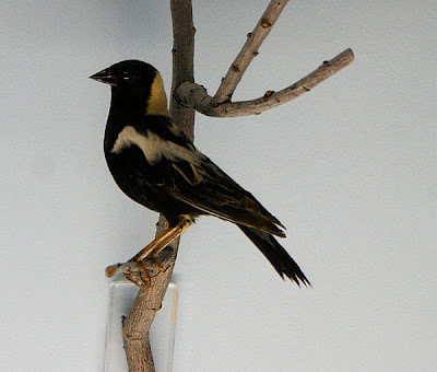
Some of the other birds were unusual in color ...

...and others in how they looked...

... it is no wonder so many people enjoy "bird watching" like
 these two...

... even the beautiful statue reflect our interest in viewing
our feathered friends.

Two beautiful black birds one with a yellow head and another with yellow
on it's wings flew in for some food... 


... and were fun to watch

We then took a drive along the auto tour that went through the entire 
refuge starting at the old Sodhouse Ranch (no, not where an old sod lived)

"The Sod House Ranch is a historic ranch in Harney County in southeastern Oregon, United States. The remaining ranch structures are located south of Malheur Lake in the Malheur National Wildlife Refuge. The ranch was built by Peter French, a well known 19th-century cattle baron. The Sod House Ranch became the headquarters for the northern operating division of the French-Glenn Livestock Company, which eventually covered over 140,000 acres."

Driving through the refuge was amazing with splashes of water surrounded by 
Tuli grasses between 6 and seven feet tall.

"In Oregon and much of the western United States, tule is the common name for two species of emergent plants that grow in shallow water of marshes, muddy shores, and lakes."

"Tule, a Spanish name, is based on tollin, of Nahurtl Native American lingustic stock, meaning a rush. Older botanical literature places these bulrushes in Scirpus, a closely related genus with various species names attached."


Some of the ponds had many birds, some birds were were very
large.


Don't ask me why this harvester was in the field but it looked cool in the
 middle of all the rushes.


Some birds were difficult to spot and others almost impossible...

...still others were impossible to find in the vegetation.

I still don't know what this tower was for and there were no signs
but it looked interesting.

Then we found the Blitzen River, and yes there is a Donner river 
nearby,that butte behind the river is called "Rattlesnake Butte" 
but we saw no snakes. 

This is the bridge over the Blitzen river where I took the last picture, 
it is a wooden bridge.


The Blitzen River is part of the nation's first redband trout reserve, established by Congress in 2000. The Redband trout is generally similar in appearance to the rainbow trout but can be differentiated by having larger, more rounded spots, parr marks that tend to remain into adulthood, are more orange-red around the lateral line, and have very distinct white tips on the anal, dorsal, and pectoral fins.

The country around eastern Oregon is amazingly beautiful and

very different from where we live in Creswell.

While driving we saw a deer up ahead going into the bushes

on the left, I knew the trees there were on the river so I got
the camera ready as we very slowly drove up and sure enough 
out came the deer and a mule deer friend - very cool.

Near the end of the drive we went by Buena Vista ponds where
a group of bird watchers had set up a roadside camp with lawn
chairs and their spotting scopes.

"At the Buena Vista ponds about 15 miles south of headquarters, plan a longer stop. Scan the marshes and ponds for American bitterns, trumpeter swans, great blue herons, great egrets, and ruddy ducks. You might want to use a spotting scope to see the far reaches of the ponds."

South of Buena Vista Ponds is the town of Frenchglen where
the Frenchglen Hotel and State Park exist. This is the dining room
where we had a great lunch.

I liked the skull on the front porch of this hotel where Our son
Isaac stayed a few months ago on a photo trip.

It must be the perspective but looking at this picture
is the Musemoblie larger than the hotel.

The Hotel is a great historic landmark for this area and the State.

They told me at the RV park this was a controlled burn it makes 

me wonder what an uncontrolled burn would look like.


Back near the RV Park I took this picture of a dead tree in Harney 
Lake. Harney Lake is a shallow alkali lake basin located in southeast 
Oregon approximately thirty miles south of the town of Burns. 

The lake lies within the boundary of the Malheur National Wildlife 
Refuge and is the lowest point in the Blitzen Valley drainage.

Our beautiful Musemobile on the edge of Malhuer lake.

Sunday, September 11, 2011

Waysides along Highway 138

 The first wayside was the Narrows Wayside and it had had a sweet and simple memorial...

 ... next to the fast moving waters of the Umpqua river...

 ... and the graceful wild flowers. Su head of the library here in Creswell, and my plant identification expert said this: "It's a bachelor's button, centaurea cyana, and it's a plant introduced here from Eurasia."

 I did venture down a bank to the river's shore...

 ... to see crystalline clear water flowing over the shallows.

 On the way back up the bank I stopped for more flowers...


 ...and more of that same type of  flower in other colors...

 ... including this beautiful white variety with lavender accents and

 ... nearby was a berry looking pod.


 Further up the road I stopped for a picture of a steep rock wall that is very typical of the area...

 ...and more of the white water spots...

 ...as well as the deeper sections of calmer water.

 I wonder why, not just my eye, my eye is so drawn to the angry white water sections with their roaring thunder than those still water sections. Perhaps it's that I'm drawn to the action/activity/power that gives the river life beyond three dimensions.

 In gardens these may be called weeds but to my eye they are beautiful delicate flowers...

 ... that form complex shapes like wound yellow wire ...

 ... or like birds on the branches of bare limbs.

Amazing and it leaks, 
"A 12-foot diameter redwood-stave flowline (pipeline) is part of the Toketee development of the North Umpqua Hydrolectric Project."

.
"Completed in December of 1949 (when I was 6 years old) , the Toketee development was the first component of the Project to be built. The Toketee facility begins at the earth-fill dam less than a mile upstream of Toketee Falls. The reservoir behind the dam is approximately 102 acres. Water enters an intake structure at the dam and then runs through the wood-stave flowline for 1,500 feet where it then transitions to concrete just before entering a tunnel through Deer Leap Rock. the water powers three generator turbines that have a capacity of 45 megawatts of electricity or enough energy for approximately 22,500 homes"
 Toketee falls is one of the most interesting falls I've seen and is a double fall waterfall. This is a picture of the falls on the information board at the trail head but we do plan to return and walk to the falls.
On the way home we took the road less traveled, a BLM road that goes up 3,500 feet then descends into Culp Creek just east of Cottage grove and while possible time wise about the same as Highway 138, was much shorter and provided this beautiful view.

No Scrabble for awhile
Quote of the Day ~
Can we ever forget 9/11 and can we afford to not learn from that tragic day
"If blood will flow when flesh and steel are one
Drying in the color of the evening sun
Tomorrow's rain will wash the stains away
But something in our minds will always stay
Perhaps this final act was meant
To clinch a lifetime's argument
That nothing comes from violence and nothing ever could
For all those born beneath an angry star
Lest we forget how fragile we are." ~ Sting from the song Fragile


Copyright

©Paul Viel